Trekking Spain’s Sendero Histórico, the GR1
The Sendero Historico (or GR1) is a trail that combines great scenery with a gentle lesson in Spain’s fascinating history. Traversing the north of Spain it sits in the shadow of world’s most famous walk, the Way of Saint James (the ‘Camino di Santiago’), and offers a completely different experience
The Sendero Historico (or GR1) is a 1250km trail that combines great scenery with a gentle lesson in Spain’s fascinating history. Spain has an impressive selection of long-distance paths and experienced Spanish walkers would tell you that this is the best of them – little known outside Spain as it may be.
Traversing the north of Spain it sits in the shadow of world’s most famous walk, the Way of Saint James (the ‘Camino di Santiago’), and offers a completely different experience. The ‘Camino’ had one aim: to get pilgrims to Santiago de Compostela as quickly as possible. It’s a sort of medieval motorway. The GR1, on the other hand, is a relatively modern invention and it’s in no rush. There is nothing direct about this route. Designed for walkers, it meanders through some of the best scenery northern Spain has to offer and, at the same time, visits key locations in the development of modern Spain.
Walking in Spain is a special experience. Spain was the last country in Western Europe to experience rural depopulation, and the remnants of an ancient infrastructure where everyone walked are still there. The GR1 follows paths and trails that, until the 1960s, were the main way people and their animals moved from village to village. Although, sadly, the days when every village had a bar, cantina or hostal have now gone, there are still just enough to make walking from place to place the best way to travel.
Travelling from west to east across Spain, the Sendero starts at the Puerto de Tarna, a pass on the regional border between the Asturias and Castilla y León, heads east along the southern flank of the Cantabrian Mountains, the plain of Navarre and the foothills of the Pyrenees (‘Prepirinio’ in Spanish) and then finishes on the Mediterranean coast at Sant Martí d’Empúries near L’Escala. Although it’s a long walk, some 1250km, and mountainous, involving over 39,000m of climb, it’s not difficult. If you’re reasonably fit, the only thing you need to enjoy it is time.
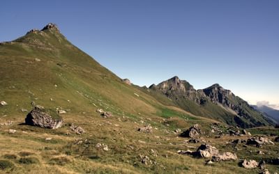
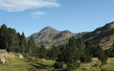
The GR1 starts near the Picos de Europa – the limestone massif that sits right in the middle of the Cantabrian Mountains, heading into Montaña Palentina and the Riaño Mountains. Although not as famous as the Picos these mountains have their own iconic peaks such as the Peña Espigüete (2451m) and Curavacas (2524m). After the Montaña Palentina comes the Burgos and Basque Mountains where the mountains are lower but just as dramatic in their own way. Depending on the ‘dip’ of the rock strata it’s a landscape formed of escarpments, ridges, cliffs and tabletop mountains or ‘mesas’. If you’ve walked in France you might be reminded of Jura or the Vercors, although this Spanish version is not quite as high.
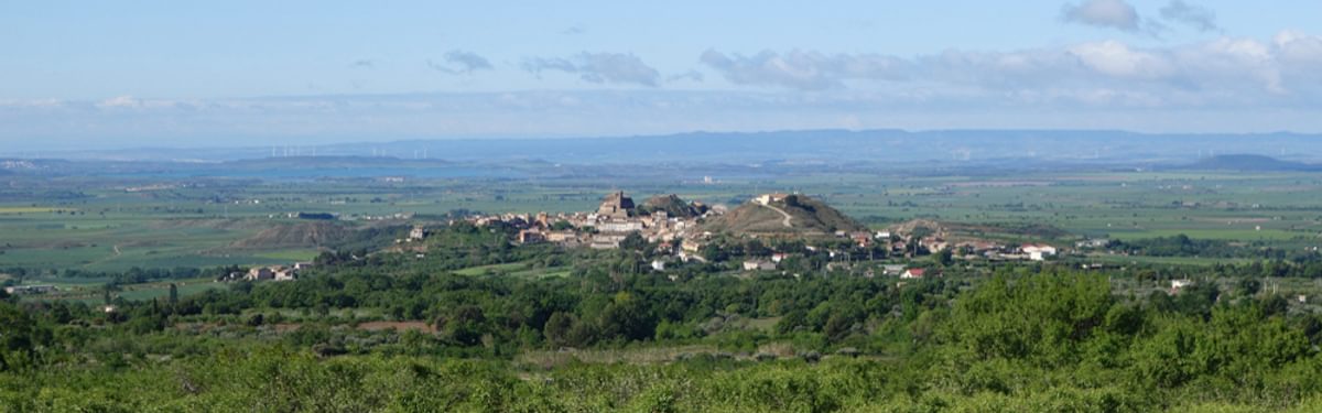
So far the route has stuck limpet-like to the southern flank of the Cantabrian Mountains with occasional views across the seemingly endless central plateau to the south. Leaving the Basque Country, and the Cantabrian Mountains, this grip slips and for three days the route takes you across the flat plain of Navarre. For most people three days will be enough, but by way of compensation you pass through Los Arcos, Lagran and Olite – beautiful little towns that sit on the plain like ships on an ocean.
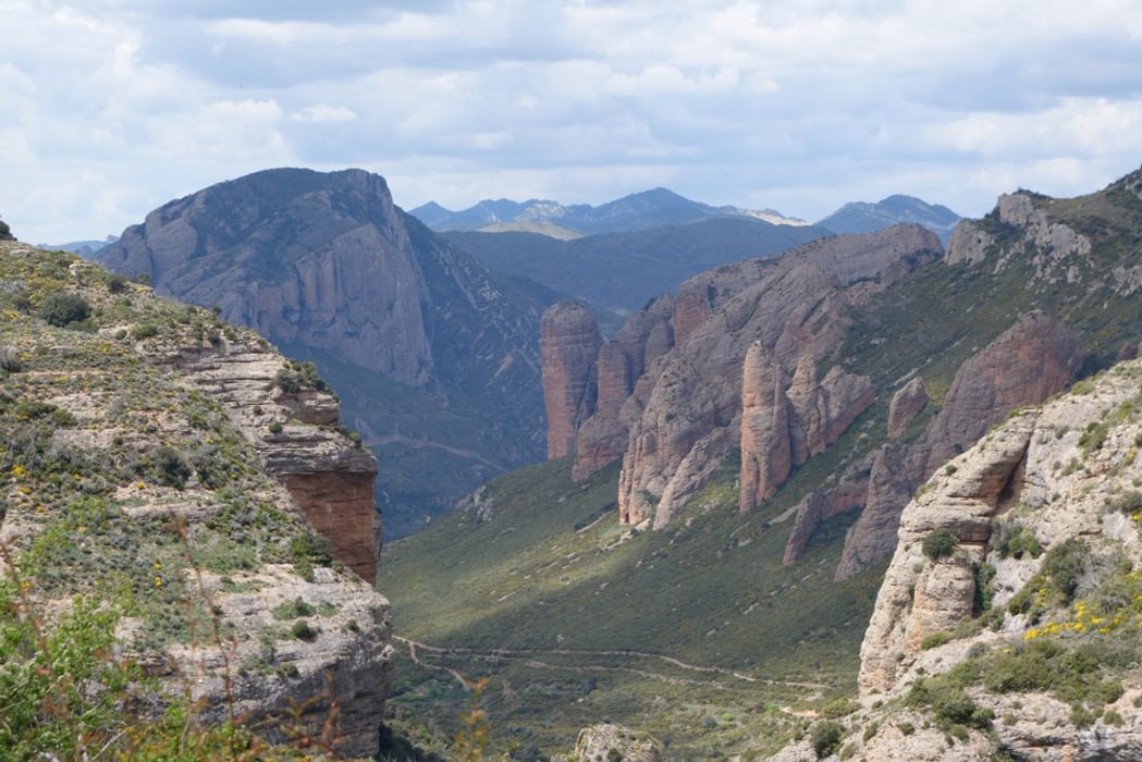
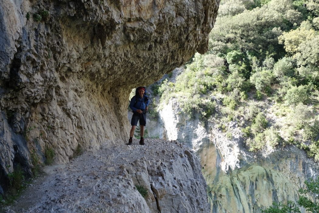
Escaping the plain the route climbs east again into the mountains and the Prepirinio – foothills of the Pyrenees. These foothills are formed of vast quantities of eroded rock debris washed down from the main mountain range into the Ebro valley and uplifted again in subsequent phases of mountain building. The result is a landscape of incredible variety but the cliffs (particularly those around Riglos which consist of a strange concrete-like conglomerate including water-eroded pebbles the size of potatoes) and the gorges (particularly those dissecting the Montsec range) are a special feature.
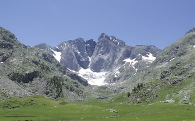
Next the GR1 crosses the north–south valleys running down from the Pyrenees and the walking is relatively arduous, with challenging daily ascents and descents. To compensate, the views of the Pyrenees are amazing, particularly if they are still covered with snow. If you’re lucky with the weather, wonderful views start as soon as you leave the plain in Navarre and continue all the way to the coast.

Spain's Sendero Historico: The GR1
Northern Spain - Picos to the Mediterranean
£17.95
Guidebook to the 1250km of Spain's Sendero Historico (GR1), traversing northern Spain from Puerto de Tarna in the province of León in the west to the Mediterranean near L'Escala in Catalonia, through fascinating, varied landscapes and the Pyrenees foothills. Described in 53 stages, about 25km each in length, with detailed mapping.
More information
What the trails are like
The GR1 follows paths originally designed to link village with village that were, until recently, the main thoroughfares as the vast majority of goods were carried by people, mules and donkeys. Many of these trails are in their original state and make for perfect walking. They are gently graded and designed for getting heavy loads steadily up and over hills. Quite often the work in constructing these routes is apparent with walls (above or below), conduits to remove water and even some of the original paving still in place. The most interesting paths are to be found in the mountains close to ancient stone villages. Here they will be walled on both sides and, just occasionally if you look closely, you can make out grooves in the carefully placed slabs of rock produced by centuries of wear from the iron rims of wagon wheels. In places a new road, capable of carrying vehicles, has been constructed to replace the original path. The old trail, with its bridges intact, is invariably more direct.
In the stages after this – to Arguis, Nocita and then Rodellar and beyond – we got to know one of the unique features of the Aragon countryside. The villages have been abandoned over the post-war period and the remnants, decaying and a little spooky, house only the occasional family and sometimes no one at all. Two centuries of urbanisation and industrialisation in Britain was compressed into two generations in Spain, and these remote communities didn’t survive the experience. Luckily for us their tracks did, and now made up our Sendero Historico.
When to walk the GR1
Much of the route is accessible all year round but there are good and not so good times to go. Factors to consider are rainfall in the winter including snow in the Cantabrian Mountains, and the heat in the summer particularly crossing the plain in Navarre. The condition of the trail will also vary from season to season and even if there isn’t a lot of snow some stretches will be so muddy that walking in winter can be uncomfortable. In addition to the weather the other factor to consider is accommodation. Much of it is available all year round but some is not open in the winter months.
The best months for most of the walk are April, May and June and September/October. July and August are good months for walking in the Cantabrian Mountains but not on lower parts of the route.
Breaking the GR1 into chunks
This guidebook is designed to provide the prospective traveller with all the information needed to plan a trip along the GR1. The complete end-to-end trail is highly recommended but it does take around 53 days to complete. Most walkers will need to break their GR1 exploration down into chunks and to this end the route is described in seven sections, each with a start or endpoint that can be easily reached by train or bus. The route is described west to east. You could, of course, choose to walk it the other way but finishing at the Mediterranean adds a certain amount of drama to the trip.
To read more articles like this get our newsletter
Sign up for 20% off your next purchase and to be the first to hear about exclusive competitions, special offers, and news from Cicerone.